Wednesday, November 23, 2011

Top Holiday Destinations India


The enchanting land of India is known for its mysterious, colourful and exotic tourist attractions. The tour of India is a unique opportunity to watch a beautiful blend of various religions, customs, festivals, sights and sounds. The country with a history dating back to 5,000 years, has the richness of culture and legend, which captivate the imagination of the visitor. The architectural gems like the temples, mosques, palaces, forts and monuments, offer an unmatched experience. In addition the geographically varied land of India is dotted with picturesque hill stations, waterfalls, lakes, rivers, lush green forests and wildlife animals. There are many places of tourist attractions in India, among the popular attractions include:


Lakshadweep:


Lakshadweep is one of the worlds most spectacular tropical island systems. Thirty- two sq. km of land spread over 36 islands surrounded by 4200 sq. km of lagoon rich in marine wealth. The precious heritage of ecology and culture is supported by an extremely fragile ecosystem. Committed to the cause of Eco tourism Union Territory of Lakshadweep has consciously followed a middle path between tourism promotion and environmental conservation. The Administration is carefully monitoring the environmental impact of coastal tourism and has taken steps to promote tourism in a way that is consistent with ecological concerns. As an effective strategy to avoid pressure on ecological environment, the efforts to promote tourism have been synchronized with the carrying capacity of the islands.

Though all the islands are endowed with the beauty of coral reef, sandy beaches, unpolluted and clear water and hospitable settings, most of these differ in terms of facilities and services offered. Some islands have been promoted for diving and water sports; still others have been developed so that people enjoy the charm of relaxation and natural enjoyment. Since the land is precious and scarce it is avowed policy of the Administration to relieve pressure on land and promote water based tourism. The motto being admires and not exploits that natural beauty.


Munnar:


Munnar - breathtakingly beautiful - a haven of peace and tranquility - the idyllic tourist destination in God's own country.

Set at an altitude of 6000 ft in Idukki district Kerala, Munnar was the favored summer resort of the erstwhile British rulers in the colonial days. Unending expanse of tea plantations - pristine valleys and mountains- exotic species of flora and fauna in its wild sanctuaries and forests - aroma of spice scented cool air - yes! Munnar has all these and more. It's the place you would love to visit - it's the place you would wish never to leave- so welcome - log on to munnar.com for all information on Munnar anytime, every time.


Darjeeling:


This list wouldn’t be complete without including this tourist destination. Starting from its humble beginnings as a cluster of villages, this was the first hill station established by the British. Located in the state of West Bengal, Darjeeling is famous for its natural beauty, tea production, trekking and awe inspiring views of Kanchenjunga ( 3rd highest peak in India)

Darjeeling is speckled with some interesting and must visit tourist attractions. Some of the remarkable places to visit in Darjeeling are Tiger Hill (gives an immense view of Peak Kanchenjunga during sun-rise), Zoo, Mahakal Temple, Singalila National Park (trekking destination), Buddhist monasteries and the Himalayan Zoo.

Along with places to see, Darjeeling offers you a range of things to do. For adventure addicts, there is mountain biking which is probably the best way to see this lovely hill station. Also a variety of trekking options along the Himalayan ridges on the Indo-Nepal border near Darjeeling. For catching the best views of Kanchenjunga, make a visit to the Shruberry Health Club. Also hitch a ride on the world famous Toy train and enjoy an unhurried way of looking at life.

For shopping addicts, the obvious best thing to buy is Darjeeling Tea which is world famous for its light taste and awesome aroma. Other noteworthy buys are local textiles, handicrafts and art. However a point to note is that the shopkeepers are more interested to cater to the foreign tourist rather than the Indian tourist (hmm colonial hangover? You bet!).

Summing it up, Darjeeling is a hill station with gives you a lot of options for places to visit, things to do and of course some awesome tea and remarkable views of Kanchenjunga. Add to it a ride in the famous Toy Train and this is an experience you will not forget soon. Darjeeling makes a compelling case for number 8 on list of best tourist places to visit in India


Cherrapunjee:


Cherrapunjee is locally and officially also known as Sohra. It is situated at a distance of 56 kms from Shillong. It is a “must see” destination for all tourists.

Cherrapunjee receives the highest rainfall in the country. The average rainfall is about 12,000 mm a year and the record for a single day was 2455 mm recorded in 1974 confirming it as the “Wettest place on Earth”. The wet town of Cherrapunji is located 4,500 feet above sea level. This is a place with ever-lasting beauty. The Mawsmai Falls are located very close to Cherrapunji and it is the 4th highest waterfall in India. They are located at a height of 1035 feet.

High above misty valleys and foaming rivers, ensconced in swirling clouds and perched on an escarpment, lies this extraordinary place of breathtaking beauty. A stunning location which earned Cherrapunji coveted entry long ago into the Guinness Book of World Records as the wettest place on earth, the place of heaviest rain where the rainfall can be recorded in feet rather than in millimetres.

Today, climatic changes have edged Cherrapunji out of the topmost ‘wet’ slot, but it still retains its pristine beauty, its unusual facets, the perpetual clouds, the perpetual mists…. Appropriately, Cherrapunji lies in the heart of the State of Meghalaya – the Abode of Clouds.


Daman & Diu:


This Union Territory of Daman and Diu and are governed from Delhi. The Daman-Ganga river divides the town in half. The southern part of the city is known as Moti(Big) Daman and the northern part known as Nani(Little)Daman.

Moti Daman is an old Portuguese area where the government buildings and old churches are located. A large wall surrounds it. And Nani Daman consists of most of the hotels of the city. The roads in Daman Diu are well maintained. Daman lies about 15kms off Vapi along the Mumbai Ahmedabad highway.

There are 39 resorts & hotels listed for Daman & Diu. Cidade De Daman seems to be a popular place to stay. Places to visit in Daman Diu are the Church of Our Lady of the Rosary and Se Cathedral, Fort at Moti Daman, the Light House, Nani Daman Fort, St. Jerome’s Fort and Beaches of Devka and Jampore.


Kodaikanal:


Yet another awesome tourist place in South India makes it to our list. For it’s hard to pronounce name, Kodaikanal is one of the most peaceful and popular hill-stations situated on the Palani Hills of Tamil Nadu, about 120 kms away from Madurai. Originally served as a refuge for the British Bureaucrats to escape from the hot plains, it has now blossomed into a popular summer retreat.

In Tamil language Kodaikanal name means “The Gift of the Forest”. Kodaikanal has many places of interest. Everywhere you go, you are surrounded with enchanting waterfalls and scenic beauty which sometimes seem straight out of a dream.
Kodaikanal has beautiful tourist attractions which are sure to wow you. The most popular one is Kodaikanal Lake (star-shaped man-made lake), bicycles and horses are available for rent at this lake to ride around the lake), Bryant Park or the Botanical Garden, Coaker’s Walk (1 km pedestrian path running along the edge of steep slopes on the southern side of Kodai), Bear Shola waterfall, Green valley view, Shembaganur museum and Guna caves are some of the other major attractions of Kodaikanal.

This quaint little hill station nestled in Tamil Nadu might not have the publicity Shimla and Manali enjoy, but is sure to give you cool climates, breathtaking scenery, lush greenery and views which are sure to stay with you for a lifetime. All this makes it a worthy entry at number 7 for the best tourist places in India


Tarkali Beach:


Situated in Sindhudurg in Southern Maharashtra, Tarkarli beach has clear waters that allow one to snorkel and scuba dive. The beach is known for its pure shores with emerald green ocean waters, so clear you could see upto 15 feet deep. The places to visit here are Sindhudurg Fort,Devbag Beach and the Backwaters.

The Malwani cuisine is quite famous here and one can have fresh fish or prawns in a thick coconut curry base. The MTDC resort is the only place of accommodations here which has 20-odd cottages on the beach front.

This place though, has been spotted by the international luxury cruise liner Hebridean Spirit and the State’s Deccan Odyssey, its largely unknown by our country people. Maybe because of the substandard treatment given to our people. There have been bad reviews about double standard treatments given to the guests in the resorts.


Wayanad:


Yet another unexplored place in Kerala, Wayanad is one of the northern districts of kerala, on its border with Karnataka. It is hilly country with a huge swathe of plantations & estates (particularly coffee estates). This mountain district is in many ways the most picturesque in the state, with its rolling hills covered with tropical rainforest.

Wayanad also contributes richly to its fortunes, with its flourishing cultivation of many spices, and also Tea, Coffee and Cocoa. Wayanad is situated at a height of 700 to 2100m above sea level with temperatures ranging from 12 to 25 degrees centigrade.

This district also has the added advantage of linking Kerala with the golden triangle of South India : Bangalore, Mysore and Ooty. Kalpetta town is the center for all the sight seeing places. An ideal place for trekking and other adventure activities.

Its famous wildflife sanctuary has got everything from exotic flora,birds and a collection of reptiles. The best time to visit is between the months of June to October. There are a number places to visit in Wayanad like Phookat lake, Eddakal caves, Kuruvadweep and Chembara Falls.


Agra-City of Taj-The symbol of Love:


A city that has three of the UNESCO World Heritage Sites is hard to keep out of this list. Located at the banks of Yamuna River, Agra is about 200 kms away from New Delhi. From its early references in the Mahabharata to being the capital of the Mughal Empire, Arga is a city that shines with examples of intricate Mughal Architecture wherever you look.

The Taj Mahal probably is best described by Rabindranath Tagore as “a teardrop on the cheek of eternity”. Attracting thousands of tourists in a day, the Taj Mahal was built by the Mughal emperor Shah Jahan for his beloved wife Mumtaz Mahal. Built in 23 years with the help of over 20000 workers, it is so perfectly designed and constructed that it looks similar from all its four sides. The Quranic inscriptions on its four entrances are carved in such subtle increase in size that may appear to be of the same size from top to bottom. Craftsmen from Italy and Persia were hired by Shah Jahan to help design his tribute of love to his wife. These and many more reasons make this monument a crowning achievement in Mughal architecture.

Apart from the awe inspiring Taj Mahal, there are many other things to do in Agra should you get the time. Other tourist attractions worth visiting are the Agra Fort, Fatehpur Sikri, Itmad-Ud-Daulah’s Tomb and Jama Masjid. If you are in the mood for a bit of shopping, you can buy various stone products, jewelry and other items. However you should be careful about being ripped off and always should bargain hard since some items can be fake. For the foodies, must have are the delicious variety of Chats and the famous pethas of Agra.

As a city, Agra might be a bit on the disappointing side with its pollution, touts and hawkers. But from a perspective of its historical significance, amazing monuments and tourist attractions, no trip to India is complete without visiting the Agra. Also it’s close proximity to the capital of India make it an ideal weekend getaway from Delhi. All this and many more reasons make Agra number 9 on our list of best places to visit in India.


Jaipur / Udaipur:


Jaipur is also popularly known as the Pink City, is the capital of the Indian state of Rajasthan. Jaipur is a very famous tourist and education destination in India.

Lots of people flock to Jaipur to view the various forts and monuments in Jaipur which reflect its glorious past. Tourism is a significant part of Jaipur’s economy. Some of the world’s best hotels are located here.

Forts & Monuments
  • Hawa Mahal
  • Amber Fort
  • Jaigarh Fort
  • Nahargarh Fort
  • City Palace
  • Jantar Mantar
  • Jal Mahal
  • Rambagh Palace
  • Chandra Mahal, The City Palace, Jaipur
  • Diwan-e-Aam, City Palace
  • Central Museum, (Albert Hall Museum)


Goa:


Goa is Famous for its pristine beaches, infact 90% of all the tourism in Goa happens only for its beautiful beaches in Coastal Areas. Goa has two main tourist seasons: winter and summer. In the winter time, tourists from abroad (mainly Europe) come to Goa to enjoy the splendid climate. In the summertime (which, in Goa, is the rainy season), tourists from across India come to spend the holidays.

In 2008 there were more than three million tourists reported to have visited Goa, more than half million of whom were from Foreign visitors. Infact, many foreigners have made Goa as there home for its laid-back and relaxed lifestyle !


Kashmir:


Kashmir was once called Heaven on Earth, and once of the most beautiful places in the world. However, in last couple of decades, terrorism has faded its charm – A place home to Himalayan Ranges.

The State of Jammu & Kashmir has main three geographical regions known as “The Lesser Himalayas” or the “Jhelum Valley” (Kashmir), “The Inner Himalayas” or “The Indus Valley” (Ladakh & Frontier areas) also called “Trans-Himalayas”, and “The Outer-Himalayas” or “The Southern mountain range” (Jammu). The area of Jammu & Kashmir is 2, 22,236 square kilometers.


Kanyakumari:


Though there are several places of tourist-interest in the town and district, Kanyakumari is especially popular in India for its spectacular and unique sunrise and sunset. The confluence of three ocean bodies – the Bay of Bengal, the Indian Ocean, and the Arabian Sea – makes the sunrise and sunset even more special. On balmy, full-moon evenings, one can also see the moon-rise and sunset at the same time – on either side of the horizon.


Kerala (Backwaters):


Kerala, situated on the lush and tropical Malabar Coast, is one of the most popular tourist destinations in India. Named as one of the "ten paradises of the world" and "50 places of a lifetime" by the National Geographic Traveler magazine, Kerala is especially known for its ecotourism initiatives, Beautiful Backwaters and Alternative healing massages.


Delhi:


Delhi, Capital of India has many attractions like mosques, forts and other monuments that represent India’s history. The important places in Old Delhi include the majestic Red Fort. New Delhi on the other hand houses many government buildings and embassies, apart from places of historical interest.
The Qutub Minar, Red Fort and Humayun’s Tomb have been declared World Heritage Sites.


Ajanta Ellora :


Ajantha & Ellora are 28 – 30 rock-cut cave monuments created during the first century BC and 5th century AD, containing paintings and sculptures considered to be masterpieces of both Buddhist religious art and universal pictorial art.

The caves are located just outside the village of Ajantha / Ellora in Aurangabad district in the Indian state of Maharashtra.

Since 1983, the Ajanta & Ellora Caves have been a UNESCO World Heritage Site.


Mysore:


Mysore is a tourism hot spot within the state of Karnataka and also acts as a base for other tourist places in the vicinity of the city. The city receives the maximum number of tourists during the period of the Dasara festival when festivities take place for a period of 10 days. One of the most visited monuments in India, the Ambavilas Palace (also known as Mysore Palace) is the center of the Dasara festivities.


Mumbai:


Think Mumbai and you think Glitz, Glamour, Movies, Fashion, Finance and of course Bhel Puri. Probably one of the most cosmopolitan cites in India, Mumbai is as diverse an experience as you can imagine. Dotted with impressive old monuments like Chhatrapati Shivaji Terminus, architectural masterpieces like the splendid Taj Mahal Hotel and the famous skyscrapers which dominate the Mumbai skyline; this is a city full of surprises and a tourist’s delight For the foodies, Mumbai boasts of some amazing street food like Pav Bhaji, Bhelpuri, Vada Pao and Pani puri. Although the hygiene standards might not be top class, the taste of the street food makes it worth a try. In case you feel adventurous and have a strong stomach, head over to Khau Galli where you are sure to find some of the best street foods in Mumbai.

In terms of tourist places in Mumbai, popular destinations include The Gateway of India, Marine Drive (semi-circular shaped natural bay along the sea coast), Hanging Gardens, Juhu Beach, Ajanta Alora Caves, Elephanta Islands and Haji Ali Dargah (Mosque). Also, if you are a shopaholic, check out the Colaba Causeway, Flora Fountain and Churchgate and the bazaars near Jyotiba Phule Market. And of course remember to bargain hard.All said and done, Mumbai is the city that dazzles with its combination of old world monuments, futuristic skyline, Bollywood Movies, great shopping avenues, tourist destinations, pristine seaside and a lot more. The city of dreams, where anything seems possible makes it to our number 6 on the best tourist places in India.


The Andaman and Nicobar Islands:


This tourist destination might not be one everyone’s list and also off the beaten track. However that does’nt means it should be missed. The Andaman and Nicobar Islands are a group of islands which lie in the Bay of Bengal. The Andaman is separated to the north while Nicobar separated towards the south. Both the islands have been separated from Thailand and Burma by the Andaman Sea. Although these islands are one of the remote places on the planet, their beauty makes them a must visit destination.

Initially the islands were populated mainly by the local people who comprise of a bunch of aboriginal tribes some of which are totally cut off from the world. Port Blair does not have a glory past where it was used as a jail for rebels and freedom fighters by the Britishers. However contrary to that gory detail, the Andaman and Nicobar islands have some of the most beautiful beaches, crystal clear waters and a good list of things to do along with places to visit.

Some of the places to see in these islands are the British colonial buildings in Port Blair (including the notorious Cellular Jail) and the World War II bunkers (awesome!). Also if you are a nature fan, check out the Neil Island which has lush green forests and pristine sandy beaches. But you shouldn’t leave these islands before having a peek at India’s only active volcano at the Barren Islands (always smoking!)

For people who love water sports, the Andaman and Nicobar Islands have a range of activities like Scuba diving, Snorkeling, Surfing. Also a must do is to see the coral reefs through a glass bottom boat at Jolly Buoy Island. If you are a land loving homo sapient, there are Camping, Trekking options as well.

The Andaman and Nicobar Island are indeed a very interesting tourist destination. They might not by your typical tourist destination but their asset lies in the un spoilt beauty, peace and quiet as well as a chance to see the only active volcano in India. Although our number 10 is an unconventional choice, we love it for this very reason. The Andaman and Nicobar islands give you a chance to go off the beaten track and experience awesome coastal tourism.

Top Holiday Destinations India & More

Kashmir Tourism | Jammu and Kashmir Tourism | Tourist Place Kashmir

Kashmir Tourism | Jammu and Kashmir Tourism | Tourist Place Kashmir


Jammu and kashmir blessed with splendid natural beauty is considered as the heaven on Earth. The Northern state of India in the Himalayan region is famous for its snow-capped. Jammu and Kashmir tourism has blossomed thanks to countless beautiful lakes, gardens and natural beauty .

The most important tourist spot in the state is Ladakh region. Famous for its Buddhist monasteries and natural beauty, today Ladakh attracts thousands of tourists every year. The tourist season in Ladakh lasts from May to October. The capital of Ladakh is Leh - famous for its monasteries. There are plenty of hotels in Leh for the tourists. Apart from Leh, tourists can visit the scenic Nubra Valley, Tsomoriri and Pangong Lake or the Kargil region. Adventure travelers will surely enjoy trekking in the Zanskar region of Ladakh.

Jammu and Kashmir is very important pilgrimage destination for Hindus. It is famous for Amarnath Yatra and Vaishno Devi shrine that attracts millions of pilgrims every year. Pilgrimage is the backbone of Jammu and Kashmir tourism.

The most important tourist destinations of state are located in Kashmir valley. Kashmir tourism has been overshadowed by terrorism by Pakistan for decades but in past few years tourists have started to come back in the valley. The popular Kashmir tourist sites are Gulmarg - a world-class ski resort, Pahalgam - the entry point of Amarnath yatra. It is a beautiful town with breathtaking views.

Srinagar, the capital of Kashmir is must visit place. The city is famous for beautiful lakes and gardens. Among very popular with tourists are Dal Lake with its famous houseboats and the Manasbal Lake. Gardens in Srinagar are CheshmaShahi Garden, Nishant Gardens and Shalimar Gardens. The other important attractions in Kashmir are Amarnath caves and Sonamarg. Tourists in Kashmir should not forget to buy local hand-looms and handicrafts.

Jammu also have some important tourist spots. The most famous is the Vaishno Devi shrine. Pantitop, Akhnoor, Jhajjar Kotti, Sanasar, Bhaderwah and Jammu City are other must visit places in Jammu region.

Gulmarg Hill Station:


Gulmarg is a town and a notified area committee in Baramula district in the Indian state of Jammu and Kashmir. Gulmarg is a hill station in Jammu and Kashmir.

During the early part of the 20th century the famous Central Asian explorer Sir Marc Aurel Stein (1862 – 1943), made his home here in a tent between his expeditions. It was a favourite summer holiday destination for the British stationed in India.

The surrounding areas were politically restive during the 1990s uprising in Kashmir, but after a ceasefire between India and Pakistan in 2003, the town is now enjoying a period of relative peace and quiet. The town is nestled within the imposing Himalayan peaks, and lies within miles of the Line of Control. It is the recipient of heavy snowfall during the winter
season and is a popular ski resort.

With the abatement of militancy in the area, Gulmarg has quickly become one of the state's most visited destinations. The slopes of the Afarwat Hills of the Pir Panjal Range of the Himalaya Chain boast one of the longest and highest ski slopes in Asia. The total distance covered by ski lift is five kilometres and the resort peaks at an altitude of 3,747m/12, 292ft, accessed by an aerial gondola (telecabine). The skiing project was inaugurated by the Chief Minister on 25 December 2004. The entire hill is guarded by the army at all times. The army, which is seen everywhere in the cities of Kashmir, is not in the town or the actual hilltop. Frisking is only done midway on the access road at 3 places: Tangmarg, near an army camp on the road from Tangmarg, and 5km before entering Gulmarg. Gulmarg does not have any permanent residents. All living in Gulmarg are hotel employees and guests. Everyone else is required to leave the village by sunset, as per curfew set by the army in 1990.

Gulmarg boasts of Asia's highest and longest cable car project, the Gulmarg Gondola. The two-stage ropeway ferries about 600 people per hour to and from Kongdoori Mountain, a shoulder of nearby Afarwat Peak (4200m/13779ft). The ropeway project is a joint venture of the Jammu and Kashmir government and French firm Pomagalski.

The first stage transfers from the Gulmarg resort at 2,600m/8,530ft to Kongdoori Station in the bowl-shaped Kongdori valley. The second stage of the ropeway, which has 36 cabins and 18 towers, takes skiers to a height of 3,747m/12,992ft on Kongdoori Mountain, a shoulder of nearby Afarwat Peak (4200m/13779ft). The second stage was completed in a record time of about two years at a cost of Rs 11 crore and opened on May 28, 2005. The French company had also built the first phase of the gondola project, connecting Gulmarg to Kongdoori, in 1998.

Gulmarg translates as "the meadow of flowers" and is located 52 km from Srinagar. Skiing is normally offered from mid-December to mid-May.

The JKSCCC has also proposed to construct chair lifts which will connect Kongdoori with Merry Shoulder peak for beginners and intermediate skiers. Gulmarg is being mooted as a possible host for the 2010 Commonwealth Winter Games.

How to Reach Gulmarg:


Taxi from Airport to Gulmarg or Srinagar to Gulmarg should be 1,200 - 1,500 Rs. There is a sign with a currently posted price of 1,200 Rs. If there is heavy snow on the pass to Gulmarg, you may want to look for a taxi with good tires or chains.

Place to Visit in Gulmarg:


The main attraction here is the Gondola. Finished in 2004, it runs up to 3995 meters. A sight seeing trip to the top of the gondola will cost you Rs. 300 for Stage one and Rs. 800 for stage two(inclusive of the cost of Stage one) for a return trip; singles (for skiiers for example!) are half the price, with a day pass available for 1200rs. You can decide whether you wish to go to Stage two when you have reached stage one. Stage two is at a much higher elevation, right on the hill top and is clearly visible from the Gulmarg taxi stand. The hills visible from the top are said to be LOC and Pakistan occupied Kashmir (specifically Nanga Parbat and (supposedly) the very tip of K2)

What to do at Gulmarg:


The main activity for a tourist in Gulmarg is snow skiing. One can enjoy skiing in the long and high slopes of the snowy mountain ranges and experience a difference.

The skiing season starts on the 25th of December and runs through to March, expect to pay 500Rs a day for ski/snowboard hire.

The weather is cold and it is necessary for the tourist to wear woollen clothes. Golfing, Sledging, and horse riding are other activities (best enjoyed in the summer). Gulmarg is likely to host the 2010 winter Olympics. And Major Tourist Attractions of Gulmarg are Alpather Lake , Baba Reshi Shrine , Gondola, Cable Car to Kongdor, Gulmarg Gold Golf , Khilanmarg, Maharani Temple, Skiing ,St Marys church,

Jammu Tourism:


Jammu is one of the three regions comprising the disputed state of Jammu and Kashmir. Jammu borders Kashmir to the north, Ladakh to the east, Himachal Pradesh to the south and Pakistan-administered Kashmir to the west.

Home to some of the most popular Hindu shrines, such as Vaishno Devi, Jammu is
one of the most famous pilgrimage tourism destinations in India. Sandwiched between the Vale of Kashmir to the north and the Daman Koh Plains to the south, the Shivalik Range comprises most of the region of Jammu. The Pir Panjal Range, the Trikuta Hills and the low-lying Tawi River basin adds beauty and diversity to the terrain of Jammu.

Many historians and locals believe that Jammu was founded by Raja Jamboolochan  in 14th century BC. During one of his hunting campaigns he reached the Tawi River where he saw a goat and a lion drinking water at the same place. The king was impressed and decided to set up a town after his name, Jamboo. With the passage of time, the name was corrupted and became "Jammu". The city name figures in the ancient book Mahabharata. The name of Jammu is also found in the memories of Timur. Excavation near Akhnoor, 20 miles from Jammu city, provides evidence that Jammu was once a part of the Harappan civilization. Remains from the Maurya, Kushan, and Gupta periods have also been found. The area witnessed the change
of control from the invading Mughals and Sikhs before finally falling under the control of the British. After independence it became a part of the Indian republic the direct successor of India itself following a bitter Kashmir war. It is said that in olden times the area now known to be as Jammu and Kashmir across the river Tawi was thick forest and was inhibited by wild animals. Once ruler of Bahu state, Raja Jambu Lochan came for hunting in this area and witnessed a Asiatic lion and a lamb drinking water at a small distance from each other on a lake. Having more satisfied their thirst, they went their own ways. The Raja was amazed and abandoned the idea of hunting and returned to his companions. Expressing what he had seen, exclaimed that this place is a place of peace and tranquillity, where a lion and a lamb can drink water side by side. The Raja commanded a palace to be built at this place and a city to be built at this place and a city to be founded around it. Thus, a city in the name of Jambu Lochan was developed and was named Jambu-Nagar which then later changed into Jammu later. Jambu Lochan was the brother of Raja Bahu Lochan who had constructed a fort on the bank of river Tavi. Bahu fort is one of the famous historical places of Jammu.

How to Reach Jammu:


Jammu is well connected by train to points south and east. It is the last rail stop  heading north, and most people only see it long enough to get from the train station to the bus stand to continue on to Srinagar.

To Srinagar there are several J&K SRTC buses taking 12 hours and costing Rs 150. Sumo 4wd jeep taxis also do this trip in less time and cost ~Rs 200 per person (or more if you wish to hire the whole taxi to yourself).

Jammu has an excellent airport which has many flights from Delhi. Kingfisher, Spice Jet, Jet Airways ,Indian Airlines,Goair and Deccan Airways have flights from Delhi

Jammu Attraction:


Vaishno Devi shrine:


The town of Katra, which is close to Jammu, is home to the famous Vaishno Devi shrine. Nestling on top of the Trikuta Hills at a height of 1700 m is the sacred cave shrine of Vaishno Devi, the mother goddess. At a distance of 48 km from Jammu, the cave is 30 m long and just 1.5 m high. At the end of the cave are shrines dedicated to the three forms of the mother goddess— Mahakali, Mahalakshmi and Mahasarasvati. Pilgrims start trekking to the cave temple which is 13 km from katra. They enter in small groups through a narrow opening and walk through ice-cold waters to reach the shrines. According to legend, the mother goddess hid in the cave while escaping a demon whom she ultimately killed.

Nandini Wildlife Sanctuary:


Areas around Jammu used to be thick forests few years ago teeming with wild life. A wildlife sanctuary, called and best known for wonderful species of pheasants. It is renowned natural habitat for a significant population of pheasants. Among the other avifauna Indian mynah, blue rock pigeon, peafowl, red jungle fowl, chir pheasants, chakor etc.

Spread over an area of 34 km², the sanctuary is rich in fauna and provides refuge to a wide variety of mammals. The main species are leopard, wild boar, rhesus monkey, bharal and grey langur.

Mansar Lake:


Situated 62 km from Jammu, Mansar is a beautiful lake fringed by forest-covered hills, over a mile in length by half-a-mile in width. Besides being a popular excursion destination in Jammu, it is also a holy site, sharing the legend and sanctity of Lake Mansarovar

Bahu Fort:


The Bahu fort, which also serves as a religious temple is situated about 5 km from Jammu city on a rock face on the left bank of the river Tawi. This is perhaps the oldest fort and edifice in the city. Constructed originally by Raja Bahulochan over 3,000 years ago, the existing Fort was more recently improved and rebuilt by Dogra rulers. There is a temple dedicated to the Goddess Kali inside the fort popularly known as Bave wali Mata. The fort overlooks the river running through Jammu city. Every Tuesday and Sunday pilgrims throng this temple and partake in "Tawi flowing worship". Bave Wali Mata is the presiding deity of Jammu. Today the fort is surrounded with a beautiful terraced garden which is a favourite picnic spot of the city folk.

Bagh-E-Bahu:


Located on the banks of Tawi river, is a famous Mughal-age garden. It gives nice view of the old city and Tawi river. Bagh itself is very beautiful. There is a small cafeteria on one side of the garden.

Raghunath Temple:


Amongst the temples in Jammu, the Raghunath Mandir takes pride of place being situated right in the heart of the city. This temple is situated at the city center and was built in 1857. Work on the temple was started by Maharaja Gulab Singh, founder of the Kingdom of Jammu and Kashmir in 1835 AD and was completed by his son Maharaja Ranbir Singh in 1860 AD. The inner walls of the main temple are covered with gold sheet on three sides.

Peer Kho Cave:


Alongside the same Tawi river are the Peer Kho Cave temple, the Panchbakhtar temple and the Ranbireshwar temple dedicated to Lord Shiva with their own legends and specific days of worship. Peer Kho cave is located on the bank of river Tawi and it is widely believed that Ramayan character Jamvant (the bear god) meditated in this cave. The Ranbireshwar Temple has twelve Shiva lingams of crystal measuring 12" to 18" and galleries with thousands of saligrams fixed on stone slabs. Located on the Shalimar Road near the New Secretariat, and built by Maharaja Ranbir Singh in 1883 AD. It has one central lingam measuring seven and a half feet height (2.3 m) and twelve Shiva lingams of crystal measuring from 15 cm to 38 cm and galleries with thousands of Shiva lingams fixed on stone slabs.

Dargah of Ali Shah:


The Dargah (shrine) of Peer Budhan Ali Shah or Peer Baba is said to protect the people of this city from mishaps and evil spirits. A friend of Guru Gobind Singh, it is said that Peer Baba lived his entire life on milk alone and lived to the age of five hundred and still people from all faiths and religions venerate him in equal respect. Peer Mitha was a saint who has a shrine of his own and was a contemporary of Ajaib Dev and Ghareeb Nath, who were famous for their prophecies and miracles. "Mitha" means "the sweet one" and the saint was so-called, as the Peer would accept nothing more than a pinch of sugar in offering from his devotees.

Srinagar Tourism:


Srinagar is the summer capital of the state of Jammu and Kashmir. he city lies on both banks of the Jhelum River, a tributary of the Indus River. The city is famous for its lakes and houseboats floating on them. It is also known for traditional Kashmiri handicrafts and dry fruits. Srinagar is 876 km north of Delhi. The headquarters of the Srinagar District are situated in the city.

Etymologically Srinagar is composed of two Sanskrit words, namely, Sri (meaning abundance and wealth) and Nagar, which means a city. Thus, the word Srinagar signifies a place of wealth and abundance. Sri is also the name of a goddess of Hindus.

A legend, as incorporated in Nila’s Nilmatapurana, states that the Kashmir valley was a vast lake. A Hindu sage named Kashyapa drained out the water, and there emerged the beautiful valley of Kashmir.

The city was founded by the King Pravarasena II over 2,000 years ago, and the city of Srinagar has a long history, dating back at least to the 3rd century BC. The city was then a part of the Maurya Empire, one of the largest empires of the Indian subcontinent. Ashoka introduced Buddhism to the Kashmir valley, and the adjoining regions around the city became a centre of Buddhism. In the 1st century, the region was under the control of Kushans and several rulers of this dynasty strengthened the Buddhist tradition. Vikramaditya (of Ujjain) and his successors probably ruled the regions just before the city fell to the control of the Huns in the 6th century, and Mihirkula was the most dreaded ruler of the city and the valley.

The Hindu and the Buddhist rule of Srinagar lasted until the 14th century, when the Kashmir valley, including the city, came under the control of the several Muslim rulers, including the Mughals. It was also the capital during the reign of Yusuf Shah Chak, a ruler who was tricked by Akbar when he failed to conquer Kashmir by force. Yusuf Shah Chak remains buried in Bihar in India. Akbar established Mughal rule in Srinagar and Kashmir valley.

How to Reach Srinagar:


By air - Flights are operated by Jet Airways, Air Deccan, SpiceJet,Kingfisher Airlines and Indian Airlines from Delhi to Srinagar, or with a stopover at Jammu. The frequency is once or twice a day by each airline. The cost is approx Rs. 2,500 from Jammu and approx Rs. 2,500-5,000 from Delhi one way. The airport is still quite small and all flights originate in Delhi, pick up passengers and then return. It is also still heavily fortified and expect to see many soldiers with guns. Winter flights can easily be canceled and leave you stranded. Tickets are easy to purchase in town, but the airport requires a ticket for entrance. A taxi into town should be Rs. 350 and direct to Gulmarg is 1,200-1,500.

By taxi - Hiring a TATA Sumo SUV (fits up to 9 people, or 5 comfortably plus luggage) from Jammu costs approximately Rs.1,900-2,700 depending on time of year or even time of day. To reduce costs many people choose not to take an exclusive taxi, and share the Sumo taxi with other travellers. This costs about Rs. 150-400 per person. For a comfortable trip, try for a seat in the middle row - the front bucket seat is (sometimes uncomfortably) shared by 2 people, and the far back is for the "vomiters".

By bus - J&K SRTC operates fairly comfortable buses from Jammu costing around Rs 150 and do the journey in around 12 hours. 2 day buses run between Srinagar and Leh staying overnight in Kargil.

Places to Visit in Srinagar:


Dal Lake:


Dal lake is a famous lake in Srinagar, Jammu & Kashmir, in India. The lake itself is connected to a number of other lakes of the Kashmir valley. It is well known for its approximately 500 Victorian-era wooden houseboats, originally built as vacation homes for landless British administrators during the Raj. The lake covers 18 square kilometers, and is divided by causeways into four basins

Shalimar Gardens:


Shalimar Gardens are the largest of the three Mughal gardens built by the Mughal emperor Jahangir. Jahangir built the gardens for his beloved and talented wife, Mehrunissa, titled Nur Jahan. The other two gardens are Nishat Bagh and Chashma Shahi.

The gardens comprise four terraces, containing a canal supplied with water from the Harwan reservoir nearby. The top garden, unseen from below, was reserved for the ladies of the court. The garden is considered to be very beautiful during the Autumn and Spring seasons due to the colour change in leaves and the blooming of flowers.

Ziarati Hazrati Youza Asouph:


Ziarati Hazrati Youza Asouph in the Khanyar area, about 150 meters NW of Dastgir Saheb mosque & shrine. This tomb, also known as Roza Bal, is believed by some to be the tomb of Jesus (part of the larger theory that he survived the crucifixion and made his way to Kashmir where he lived until at least the age of 100). It has been made popular by recent books such as Jesus Lived in India by Holger Kersten among others. It's down a little side road - ask around, pretty much anyone in the area can point you in the right direction.

Nishat Bagh :


Nishat Bagh is one of the three Mughal gardens on the edge of Dal Lake in Srinagar, India. The garden was built for a brother of Mughal emperor Nur Jahan. From the lake edge, Nishat Bagh rises through 12 terraces along a broad central canal toward the nearby mountains. Chadars, sloping chutes, funnel water through each terrace to rectangular pools studded with fountain jets.

Shankaracharya temple:


Shankaracharya Temple and Shanakracharya is believed to have visited the place and meditated there. Most of the Kashmiris know this place by the name of "Sulaiman Teng". The historians believe that before the temple was built on this site, their used to be a mosque, which was later removed by the Hindu rulers.

Kheer Bhavani shrine:


Kheer Bhavani shrine located about 26 km from Srinagar is one of the most revered Hindu Shrines of Kashmir. It has a spring which changes colours indicating the fortunes of people.

Hari Parbat hill:


Hari Parbat hill situated in the centre of Srinagar, is the site of a Durrani fort, Sufi saint Sheikh Hamza Makhdoom's Shrine, an ancient Hindu temple to the goddess Sharika Devi(Parvati).

Kashmir Tourism | Jammu and Kashmir Tourism | Tourist Place Kashmir

Wednesday, November 9, 2011

Places to visit in Coorg Karnataka


Coorg Tourism
Kodagu is an administrative district in Karnataka State in southern India. It is also known by its anglicised former name of Coorg. It occupies an area of 4,102 square kilometres (1,584 sq mi) of land in the Western Ghats of southwestern Karnataka. As of 2001, the population was 548,561, with some 13.74% of the population residing in the district's urban centres.

Madikeri is the headquarters of the Kodagu district. The district is bordered by Dakshina Kannada district to the northwest, Hassan district to the north, Mysore district to the east, the Kannur District of Kerala to the southwest, and the Wayanad District of Kerala to the south.

Coorg TourismKodagu is located on the eastern slopes of the Western Ghats. It has a geographical area of 4,102 km2 (1,584 sq mi). The district is bordered by Dakshina Kannada district to the northwest, Hassan district to the north, Mysore district to the east, the Kannur District of Kerala to the southwest, and the Wayanad District of Kerala to the south. It is a hilly district with the lowest elevation in the district at 900 metres (3,000 ft) above sea-level. The highest peak, Tadiandamol, rises to 1,750 metres (5,740 ft), with Pushpagiri, the second highest, at 1,715 metres (5,627 ft). The main river in Kodagu is the Kaveri (Cauvery). The Kaveri starts at Talakaveri, located on the eastern side of the Western Ghats, and with its tributaries, drains the greater part of Kodagu.

Coorg Tourism
In July and August, rainfall is intense, and there are often showers into November. Yearly rainfall may exceed 4,000 millimetres (160 in) in some areas. In dense jungle tracts, rainfall reaches 3,000 to 3,800 millimetres (120 to 150 in) and 1,500 to 2,500 millimetres (59 to 98 in) in the bamboo district to the west. Kodagu has an average temperature of 15 °C (59 °F), ranging from 11 to 28 °C (52 to 82 °F), with the highest temperatures occurring in April and May. The principal town, and district capital, is Madikeri, or Mercara, with a population of around 30,000. Other significant towns include Virajpet (Virarajendrapet), Kushalnagar, and Somwarpet. The district is divided into the three administrative talukas (divisions) of Madikeri, Virajpet and Somwarpet.

How to Reach Coorg


By Air: The nearest airport is Mysore Airport which is 120 KM away and Mangalore International Airport around 180 km away. Private taxies & buses are easily availble from here to reach Coorg.

By Rail: The nearest railway stations from Coorg are Thalassery, Mysore and Hassan.

By Road: Coorg is very well connected by road to the major cities of India.

Below are some important distance from Coorg:

Coorg to Mysore - 120 km
Coorg to Hassan - 115 km
Coorg to Mangalore - 135 km
Coorg to Bangalore - 250 km

Best Time to Visit Coorg


November to April is the best time to visit Coorg.

Map of Coorg


Coorg Weather


Places to visit in Coorg


Talakaveri


Talakaveri Coorg
Talacauvery, is the place that is generally considered to be the source of the Cauvery River. It is located in the Brahmagiri hill (not to be confused with the Brahmagiri range further South) near Bhagamandala in Kodagu district, Karnataka, 1,276 m. above sea level. However, there is not a permanent visible flow from this place to the main rivercourse except during the rainy season.

A tank or kundike has been erected on a hillside, at the place that is said to be the origin. It is also marked by a small temple, and the area is frequented by pilgrims. The Kaveri River originates as a spring feeding this tank, which is considered to be a holy place to bathe on special days. The waters are then said to flow underground to emerge as the river some distance away. The temple has been renovated extensively by the state government recently.

On Tulasankramana day (the first day of Tula Masa month, according to the Hindu calendar, which normally falls in mid October) thousands of pilgrims flock to the river's birthplace to witness the rise of the fountainhead, when water gushes up from the spring at a predetermined moment. The tula snanam (Sacred bath in the Tula month) is observed across pilgrim towns in Kaveri's banks.

Talacauvery is about 8 km away from Bhagamandala and 48 km from Madikeri.

Irupu Falls


Irupu Falls Coorg
The Irupu Falls (also Iruppu Falls) are located in the Brahmagiri Range in the Kodagu district of Karnataka, India, bordering the Wayanad district of Kerala. It is a fresh water cascade and is situated at a distance of 48 km from Virajpet on the highway to Nagarhole. The Falls are also known as the Lakshmana Tirtha Falls, derived from the name of the tributary of Cauvery which starts from these falls, the Lakshmana Tirtha River.

A forest trail leads from these falls to the Brahmagiri Peak in Southern Kodagu. Irupu falls is a major tourist attraction as well as a pilgrimage spot. A famous Siva temple, the Rameshwara Temple is situated on the banks of the Lakshmana Tirtha River, en route to the Falls. This temple attracts a large number of pilgrims during the festival of Shivaratri.

Abbey Falls


Abbey Falls Coorg
Abbey Falls (also spelled Abbi Falls and Abbe Falls) is in Kodagu, in the Western Ghats in Karnataka, India. It is located 8 km from the town of Madikeri and 268 km from Bangalore.

In the mountains of the Western Ghats, several streams combine, swelling with the monsoon rains and plunging down the mountain slope at enormous speed, hitting the huge boulders hard and forcing through the crevices and ravines. A misty cloud hangs over the falls. From here the water flows into the Kaveri River. During the monsoon season the water flow is very high. During the dry seasons the flow is considerably diminished.One can find a lot of leeches inside the water.

The waterfall is located between private coffee plantations with stocky coffee bushes and spice estates with trees entwined with pepper vines. The falls appear suddenly, the water cascading over rocks into calm pools. A hanging bridge constructed just opposite the falls comes in handy for the Tourists. There is a Kali Mata temple on the other side of the bridge and Coffee and Black Pepper trees on the other side.

Dubare


Dubare Coorg
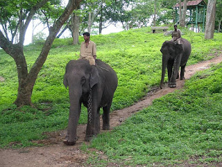
Dubare is known for its elephant camp, and is a forest camp on the banks of the river Kaveri in the district of Kodagu, Karnataka. It is an important base for the Karnataka Forest Department's elephants.

The elephants for the Mysore Dussehra were trained at Dubare elephant camp. At present, after logging operations have ceased, the elephants have been practically retired except for giving some rides to tourists.

In addition to elephant training camp, Nisargadhama and Veerabhoomi are the other main attractions of the forest area.

There are opportunities for trekking, elephant rides, fishing, and river rafting. these activities are hosted by Jungle Lodges and resorts. The Forest Department also conducts some treks along well-defined routes.

The moist deciduous forests of Dubare are home to many wild animals and birds. Sighting of wild Asiatic elephants are regular and so is spotting the sambhar and the spotted deer. tiger, leopard, wild dogs, gaur and bears are also seen in these forests. Crocodiles can be seen in river. The forests are also home to many reptiles non-venomous snakes.

Birdlife in Dubare includes peacock, partridge, kingfisher and woodpeckers topping the list.

Dubare is easily accessible from Bangalore. The route from Bangalore is via Mysore, Kushalanagara, Gudde Hosur (4km from Kushalanagara on BM Road), then turn towards Siddapura. About 15 kilometer on the Siddapura Main Road visitors would find a Dubare Camp board.

Chiklihole Reservoir Dam


The unique thing about this dam is the scenic way in which water is allowed out of the reservoir.Roads are decent, but not wide enough for buses.

Nagarhole National Park


Nagarhole National Park Coorg
Nagarhole National Park, also known as "Rajiv Gandhi National Park", is located 94 kilometers (58 mi) from Mysore in Karnataka in South India. It is spread between Kodagu district and Mysore district. Located to the north-west of Bandipur National Park, Kabini reservoir separates the two. The park has rich forest cover, small streams, valleys, and waterfalls. The park has a healthy tiger-predator ratio, and tiger, Indian bison, and elephant are much more populous here than in Bandipur.

The park stretches over 643 square kilometres (248 sq mi), protecting the wildlife of Karnataka. Together with the adjoining Bandipur National Park (870 km2 (340 sq mi)), Mudumalai National Park (320 km2 (120 sq mi)) and Wayanad Wildlife Sanctuary (344 km2 (133 sq mi)), it forms the largest protected area in Southern India, totalling 2,183 km2 (843 sq mi).

The park is part of the Nilgiri Biosphere Reserve. The Western Ghats, Nilgiri Sub-Cluster (6,000+ km²), including all of Nagarhole National Park, is under consideration by the UNESCO World Heritage Committee for selection as a World Heritage Site.

Bhagamandala


Bhagamandala is a pilgrimage place in Kodagu, Karnataka, in India. It is situated on the river Kaveri in its upstream stretches. At this place, the Kaveri is joined by two tributaries, the Kannike and the mythical Sujyoti river. It is considered sacred as a river confluence (kudala or triveni sangama, in Kannada and Sanskrit respectively).

It is a common practice for pilgrims to take a dip in the triveni sangama and perform rituals to their ancestors before proceeding to Talakaveri, the birthplace of Kaveri. During Tula Sankramana which falls on October 17th or 18th, pilgrims assemble here in large numbers.

Dargah Sharief of Yemmemadu


Dargah Sharief, the Holy Tomb, of Yemmemadu is one of the most sacred shrines for Muslims in Kodagu district. (35 km from Madikeri; Madikeri-Bettageri-Napoklu-Hale Taluku-Yemmemadu)

Mandalapatti


28 km from Madikeri. On the way to Abbey Falls, before 3 km from Abbey Falls take right, from there 25 km.

Hotels in Coorg


Solitaire Exotica Resort
Hotel Hill View
Hotel Rajdarshan
Hotel Hilltown
Green Lines Stays
Hotel Heritage Resort
Orange County Resort
Green Hills Estate
Hotel Capitol Village Resort
Kannika International
Alpen Glow Homestay
Hotel Polaycad Estate
Hotel Kadkani Riverside Resorts

Coorg Photos


Coorg

Coorg

Coorg

Coorg

Coorg

Coorg

Coorg

Coorg

Coorg


Coorg

Coorg

Coorg Tourism | How to Reach Coorg | Best Time to Visit Coorg | Map of Coorg | Coorg Weather | Places to visit in Coorg | Hotels in Coorg | Coorg Photos | Hill Station in India

Wednesday, October 19, 2011

Nainital Hill Station | Nainital Uttaranchal

About Nainital


Nainital Tourism
Nainital is a town in the Indian state of Uttarakhand and headquarters of Nainital district in the Kumaon foothills of the outer Himalayas. Situated at an altitude of 1,938 metres (6,358 ft) above sea level, Nainital is set in a valley containing a pear-shaped lake, approximately two miles in circumference, and surrounded by mountains, of which the highest are Naina (2,615 m (8,579 ft)) on the north, Deopatha (2,438 m (7,999 ft)) on the west, and Ayarpatha (2,278 m (7,474 ft)) on the south. From the tops of the higher peaks, "magnificent views can be obtained of the vast plain to the south, or of the mass of tangled ridges lying north, bounded by the great snowy range which forms the central axis of the Himalayas." It is also one of the famous hill stations in India.

Nainital has temperate summers, maximum temperature 27 °C (81 °F); minimum temperature 7 °C (45 °F), during which its population increases more than fivefold with an annual influx of tourists predominantly from the plains of Northern India. In the winter, Nainital receives snowfall between December and February with the temperatures varying between a maximum of 15 °C (59 °F) and a minimum of −3 °C (27 °F).

Nainital
As of the 2001 Indian census, Nainital had a population of 38,559. Males constitute 54% of the population and females 46%. Nainital has an average literacy rate of 91%, higher than the national average of 59.5%: male literacy is 98%, and female literacy is 86%. In Nainital, 1% of the population is under 6 years of age. Kumaonies form the major part of the town's population along with people from all over India.

It is believed that Nainital figures in some ancient myths of India. In the Manas Khand of the Skand Puranas, Nainital Lake is called Tri-Rishi-Sarovar, hinting at the story of three sages (or rishis), Atri, Pulastya and Pulaha, who, upon finding no water in Nainital, dug a large hole at the location of the present day lake (sarovar = lake) and filled it with water from the holy lake Manasarovar in Tibet. According to lore, a dip in Naini Lake, "the lesser Manasarovar," earns merit equal to a dip in the great lake.

Nainital
Nainital is definitely a heaven for all the adventure finders. It presents loads and loads of activities related to adventure. For example fun time jeep tours, caving, river rafting, kayaking, horse riding, and rock climbing, trekking and yacht.

It is also believed that The Naini Lake is one of the 64 Shakti Peeths, or religious sites where parts of the charred body of Sati (Parvati) fell on earth while being carried by Lord Shiva. The spot where Sati's eyes (or Nain) fell, came to be called Nain-tal or lake of the eye. The goddess Shakti is worshipped at the Naina Devi Temple on the north shore of the present day lake.

History of Nainital


Nainital
The Kumaon Hills came under British rule after the Anglo-Nepalese War (1814–16), but the hill station town of Naini Tal was founded only in 1841, with the construction of the first European house (Pilgrim Lodge) by P. Barron, a sugar trader from Shahjahanpur. In his memoir, he wrote: "It is by far the best site I have witnessed in the course of a 1,500 miles (2,400 km) trek in the Himalayas." In 1846, when a Captain Madden of the Bengal Artillery visited Naini Tal, he recorded that "houses were rapidly springing up in most parts of the settlement: some towards the crest of the limitary ranges were nearly 7,500 ft (2,300 m) above sea level: the rugged and woody Anyarpatta (Anyar-patt - in Kumaoni means - complete blackout. The reason for this nomenclature by the localites was because there were minimal sun rays due to its location and dense forests) was being gradually planted and that the favourite sites were on the undulating tract of forest land which stretched back from the head of the lake to the base of China and Deopatta (Camel's Hump). The Church, St. John in the Wilderness, had been built, ..." Soon, the town became a health resort favoured both by British soldiers and by colonial officials and their families trying to escape the heat of the plains. Later, the town also became the summer residence of the Governor of the United Provinces.

Nainital
In September 1880 a landslide (the Landslip of 1880) occurred at the north end of the town, burying 151 people. The first known landslide had occurred in 1866, and in 1879 there was a larger one at the same spot, Alma Hill, but "the great slip occurred in the following year, on Saturday 18 September 1880." "Two days preceding the slip there was heavy rain, ... 20 inches (510 mm) to 35 in (890 mm) fell during the 40 hours ending on Saturday morning, and the downpour still lasted and continued for hours after the slip. This heavy fall naturally brought down streams of water from the hill side, some endangering the Victoria Hotel, ... (which) was not the only building threatened ... Bell's shop, the Volunteer Orderly Room and the Hindu (Naina Devi) temple were scenes of labour with a view to diverting streams. At a quarter to two the landslip occurred burying those in and around the buildings mentioned above." The total number of dead and missing were 108 Indian and 43 British nationals. (See poem by Hannah Battersby on the page Literary references to Nainital). The Assembly Rooms and the Naina Devi Temple were both destroyed in the disaster. A recreation area known as 'The Flats' was later built on the site and a new temple was also erected. To prevent further disasters, storm water drains were constructed and building bylaws were made stricter.

Establishment of schools


Nainital
In the latter half of the 19th century a number of "European" schools for boys and girls were founded in Nainital. During the Victorian and Edwardian eras, students in these schools consisted largely of children of British colonial officials or soldiers. In 1906, for example, there were over half a dozen such schools, including the Diocesan Boys' School (later renamed Sherwood College) under the guidance of the Church of England; Philander Smith's College (now, Birla Vidya Mandir), maintained by an American; St. Joseph's College a Roman Catholic institution, Wellesley School an American institution; St. Mary's Convent High School, a Roman Catholic institution; All Saints Diocesan High School for Girls, under the Church of England, and Petersfield College for Girls.

In the 1920s and 30s, the schools began to admit more Indian students. This trend continued until independence, by which time the student bodies had become predominantly Indian, albeit in many cases greatly reduced in size.

Transition


Nainital
By the 1880s, a mere 42 years after its founding, Nainital had become something of an exclusive English preserve, with the Indian presence in the town confined largely to a behind-the-scenes labour and service industry, or to the occasional prince. This state of affairs lasted for much of the Victorian era. The first signs of change came early in the 20th century, when Indian bureaucrats and professionals began arriving in town as part of the annual migration of the state government of the United Provinces to Nainital every summer. By 1901 its population had risen to 7,609.

The next big change came in 1925, when British civil servants began to receive subsidies for taking their annual vacations in England, and, consequently, many stopped going to the hill stations in the summers. From then on until 1947 (excepting the war years), the British presence in Nainital (measured, for example, by home ownership) continued to decline and was gradually replaced by a burgeoning Indian presence.

How to Reach Nainital


By Air: The nearest airport is Pantnagar airport situated at 70 KM from Nainital. Private taxies are easily available from here to reach Nainital.

By Rail: The nearest railway station from Nainital is Kathgodam situated at 35 KM from Nainital. It is very well connected with Lucknow, Agra and Bareilly. Private taxies are easily available from here to reach Nainital.

By Road: Nainital is well connected with the other cities by road. Private & public buses are easily available to reach Nainital.

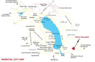
Map of Nainital


Nainital Map

Places to Visit in Nainital


Naina Devi Temple


Naina Devi Temple Nainital


The Naina Devi Temple was destroyed by the landslip of 1880 and later rebuilt. It is located on the northern shore of Naini Lake. The presiding deity of the temple is Maa Naina Devi represented by two Netras or eyes. Flanking Naina Devi are the deities of Mata Kali and Lord Ganesha.

The church of St. John in the Wilderness

The church of St. John in the Wilderness was established in 1844 and is located on the north end of town (Mallital), about half a mile north-west of the Naina Devi temple. The church was so named by Daniel Wilson, the Bishop of Calcutta, who, after falling ill during a visit to Nainital in 1844 to lay the foundation of the church, was obliged to sleep in an unfinished house on the edge of the forest. (See excerpt from Josiah Bateman on the Literary references to Nainital page.) A brass plaque on the altar is inscribed with names of the victims of the Landslip of 1880.

Governor’s House

Governor’s House also known Raj Bhavan and formerly, Government House was built in 1899 and designed in the Victorian Gothic domestic style (also called "domestic Gothic") by the architect F.W. Stevens. Originally built as the summer residence of the governor of the North West Province, it later became the summer residence for the Lieutenant Governor of the United Provinces. Currently, Raj Bhavan is the official guest house for the governor of Uttarakhand and for visiting state guests. The complex consists of a two-storied mansion with 113 rooms, a large garden, a swimming pool, and golf links. Obtaining prior permission is must for visiting.

Snow View


Snow View Nainital


Snow View is situated at an altitude of 2,270 m (7,450 ft) and located atop the Sher-ka-danda Ridge (north by north-east of the town centre), is easily reachable by cable car.Charges for cable car is Rs. 150 per person, Rs. 75 for child. Charges are for stay for one hour at the point. Timings are 10.00a.m. to 5.00p.m. On a clear day, it offers spectacular views of the snowbound high Himalaya, including Nanda Devi, Trisul, and Nanda Kot. The best time of the year for viewing the mountains is late October and November. (See excerpts from Joseph Fayrer on the Literary references to Nainital page.)

Naina Peak


Naina Peak Nainital


Naina Peak also known as China or Cheena Peak. Naina peak is the highest peak in the town, with an altitude of 2,615 m (8,579 ft). and at a walking distance of 6 km (3.7 mi) from the north end of the town (Mallital). From atop the peak, one can not only see a broad swath of the snow clad high Himalaya, but also obtain a panoramic view of Nainital town itself. The summit is an invigorating hike from Nainital town; in addition, for the less energetic visitors, ponies can be hired in Mallital or on Snow View.

Tiffin Top

Tiffin Top also known as Dorothy's Seat (Tiffin = light meal eaten during the day). This terraced hill top (2,292 m (7,520 ft)) on Ayarpatta hill is a 4 km (2.5 mi) hike from the town centre and commands a nice view of the neighbouring country side. Dorothy's Seat is a stonework picnic perch on Tiffin Top built as a memorial to an English artist, Dorothy Kellet, by her husband and admirers after her death in a plane crash.

Bhimtal Lake

Bhimtal Lake is named after the second Pandava brother Bhima in the Mahābhārata who was known for his prodigious strength. The lake, which is larger than Naini Lake, is approximately 22 km (14 mi) from Nainital at an altitude of 1,370 m (4,490 ft). There is an island in the lake with a popular restaurant on it. There is also a 17th century temple complex, the Bhimeshwar, alongside a 40 ft (12 m) high dam at one end of the lake.

Sattal

Sattal, literally Seven Lakes, is at a distance of about 23 km (14 mi) from Nainital in the Lower Himalayan Range at an altitude of 1,370 m (4,490 ft). It is a cluster of small interconnected lakes in the midst of an old oak forest. On approaching Sattal, the first lake encountered is the Nal-Damyanti Lake; next it is the Panna or Garude lake; and finally there is a cluster of three lakes: Ram, Laxman, and Sita lakes.

Khurpa Tal

Khurpa Tal, literally Trowel Lake, is an attractive lake about 10 km (6.2 mi) by road (or a 5 km (3.1 mi) hike) from Nainital at an altitude of 1,635 m (5,364 ft). It is popular with anglers and is surrounded by terraced fields (or farms), from which it presumably gets its name.

Naukuchia Tal

Naukuchia Tal, literally, Nine-Cornered Lake, is 26 km (16 mi) from Nainital and 4 km from Bhimtal at an altitude of 1,220 m (4,000 ft). The lake is almost 1 km (0.62 mi) long, 0.5 km (0.31 mi) wide and approximately 40 m (130 ft) deep. It is the deepest of the lakes in the greater Naintal area. According to legend, if one takes in all nine corners in one glimpse, one can disappear in a cloud of smoke. (See excerpts from J. W. M'Crindle on the Literary references to Nainital page.)

Hanumangarhi

Hanumangarhi, also known as Hanuman Garh, is located at an altitude 1,951 m (6,401 ft). The temple complex is about 3.5 km (2.2 mi) from the Tallital (South End) bus stop. The presiding deity of the temple is Lord Hanuman, the vanara god of the Ramayana, and he is depicted tearing open his chest to reveal Rama and Sita in his heart. Hanuman Garhi is also known for its spectacular views of the setting sun. Ranikhet is a hill station and cantonment town in Almora district.

Kumaon University

Nainital is home to one of the two campuses of Kumaon University (the other being Almora 'SSJ Campus'). The university was founded in 1973 when it incorporated the Dev Singh Bisth (DSB) Government College (commonly called "the Degree College"), which had been founded in 1951 by Thakur Dan Singh Bist in memory of his late father, with the mathematician Dr. A.N. Singh as its first principal.

Nianital Weather Forcast


Hotels in Nainital


Garden Valley Resort
Prim Rose
Rewa Retreat
Hotel Sunrise
Hotel Maharaja
Bob's Place
Alpine Club
Lakeside Inn
Hotel New Bharat
Chevron Fairhavens
Arif Castles

Nainital Tourism | Places to Visit in Nainital | Nainital Photo | Nainital Hill Station | Nainital Uttaranchal

Related Posts Plugin for WordPress, Blogger...